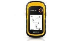
Garmin eTrex 30x 010-01508-10 Handheld Navigator
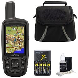
The new eTrex 30x is our upgraded version of the popular eTrex 30, with enhanced screen resolution and expandedinternal memory so you can download a greater variety of maps than ever. This rugged, dependable GPS retains the easeof-use and affordability that eTrex is legendary for, with an array of compatible mounts for use on ATVs, bicycles, boatsand cars. The new eTrex 30x also has the ability to track both GPS and GLONASS satellites simultaneously. Add to that a3-axis tilt-compensated electronic compass and barometric altimeter, and you’re ready to confidently go anywhere.
Product Features
- UPGRADED DISPLAY – Features a 2.2″ 65K color sunglight readable display offering increased resolution (240 x 320 pixels). Physical dimensions: 2.1″ x 4.0″ x 1.3″ (5.4 x 10.3 x 3.3 cm)
- LOAD MORE MAPS – Large 3.7 GB of internal memory and microSD card slot lets you load a variety of maps, including TOPO 24K, HuntView, BlueChart g2, City Navigator NT and BirdsEye Satellite Imagery (subscription required)
- PRELOADED BASEMAP – Includes a worldwide basemap with shaded relief
- BUILT-IN SENSORS – eTrex 30x adds a built-in 3-axis tilt-compensated electronic compass and a barometric altimeter which tracks changes in pressure to pinpoint your precise altitude, and you even can use it to plot barometric pressure over time
- WIRELESS – Wirelessly share your waypoints, tracks, routes and geocaches with other compatible devices -simply press “send” to transfer your information -also wirelessly connects to compatible Garmin devices, including VIRB and accessory sensors.











I like this unit I like this unit. I was using a Garmin GPSMap 60CSX (now my backup) and this unit aquires much faster and is more accurate. With the ability to use larger Micro SDCards, I grabbed many free maps online, made some of my own, and purchased the Topo 24k from Garmin. It’s small, light, and last almost 24 hours on battery for me. I bought the backpack attachment, but also printed a couple of clip accessories I found on Thingiverse. I’m happy!! Also, it is rated IPX7 which seems to be defined…
Worth every penny for the rucker! Bought this and the topo maps for NA parks. I used this on a 1 week solo hike across Michigan’s Upper Peninsula and the trail I was on North Country Trail was on there for my entire 140 miles. It was nice to open it up and see distances to my way points because I could calculate based on my speed and terrain when I would arrive.I had to change the batteries 2 times which was no big deal as I have a Goal Zero solar kit on the top of my bag that I use for charging batteries and my…